plot3m
Project 3-D lines and points on map axes
Syntax
h = plot3m(lat,lon,z)

h = plot3m(lat,lon,linespec)

h = plot3m(lat,lon,PropertyName,PropertyValue,...)
Description
h = plot3m(lat,lon,z) displays
projected line objects on the current map axes. lat and lon are
the latitude and longitude coordinates, respectively, of the line
object to be projected. Note that this ordering is conceptually reversed
from the MATLAB® line function, because the vertical (y)
coordinate comes first. However, the ordering latitude, then longitude,
is standard geographic usage. lat and lon must
be the same size, and in the AngleUnits of the
map axes. z is the altitude data associated with
each point in lat and lon. The
object handle for the displayed line can be returned in h.
The units of z are arbitrary, except when
using the globe projection.
In the case of globe, z should
have the same units as the radius of the earth or semimajor axis specified
in the 'geoid' (reference ellipsoid) property
of the map axes. This implies that when the reference ellipsoid is
a unit sphere, the units of z are earth radii.
h = plot3m(lat,lon,linespec) where linespec
specifies the line style.
h = plot3m(lat,lon, allows
the specification of any number of property name/property value pairs
for any properties recognized by the MATLAB PropertyName,PropertyValue,...)line function
except for XData, YData,
and ZData.
Examples
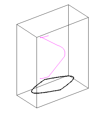
axesm sinusoid; framem; view(3)
[lats,longs] = interpm([45 -45 -45 45 45 -45]',...
                       [-100 -100 100 100 -100 -100]',1);
z = (1:671)'/100;
plot3m(lats,longs,z,'m')
Tips
plot3m is the mapping equivalent of the MATLAB plot3 function.